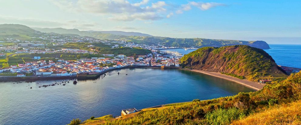
The Azores, is one of the two autonomous regions of Portugal (along with Madeira (Região Autónoma da Madeira). It is an archipelago composed of nine volcanic islands in the North Atlantic Ocean about 1,360 km (850 mi) west of continental Portugal, about 1,643 km (1,021 mi) west of Lisbon, in continental Portugal, about 1,507 km (936 mi) northwest of Morocco, and about 1,925 km (1,196 mi) southeast of Newfoundland, Canada. Its main industries are agriculture, dairy farming, livestock, fishing, and tourism, which is becoming the major service activity in the region. In addition, the government of the Azores employs a large percentage of the population directly or indirectly in the service and tertiary sectors. The main capital of the Azores is Ponta Delgada. There are nine major Azorean islands and an islet cluster, in three main groups. These are Flores and Corvo, to the west; Graciosa, Terceira, São Jorge, Pico, and Faial in the centre; and São Miguel, Santa Maria, and the Formigas Reef to the east. They extend for more than 600 km (370 mi) and lie in a northwest-southeast direction. All the islands have volcanic origins, although some, such as Santa Maria, have had no recorded activity since the islands were settled. Mount Pico, on the island of Pico, is the highest point in Portugal, at 2,351 m (7,713 ft). If measured from their base at the bottom of the ocean to their peaks, which thrust high above the surface of the Atlantic, the Azores are actually some of the tallest mountains on the planet. The climate of the Azores is very mild for such a northerly location, being influenced by its distance from the continents and by the passing Gulf Stream. Due to the marine influence, temperatures remain mild year-round. Daytime temperatures normally fluctuate between 16 °C (61 °F) and 25 °C (77 °F) depending on season. Temperatures above 30 °C (86 °F) or below 3 °C (37 °F) are unknown in the major population centres. It is also generally wet and cloudy. The culture, dialect, cuisine, and traditions of the Azorean islands vary considerably, because these once-uninhabited and remote islands were settled sporadically over a span of two centuries.
Map of Azores Islands

Capital City: Ponta Delgada
Currency
Climate
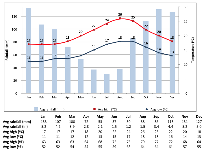
The northern coast of the island of São Miguel around Capelas and São Vicente (between Ribeira Grande and Ponta Delgada). The archipelago is spread out in the area between 37° N and the parallels of latitude that pass through the Lisbon area (38° 43′ / 38° 55′ N), giving it a generally tepid, oceanic, subtropical climate, with mild annual oscillations. Daily maximum temperatures usually range between 15 and 25 °C (59 and 77 °F). The average annual rainfall increases from east to west, ranging from 700 to 1600 millimetres (27.6–63 in) in the east, and reaching 6,300 millimetres (250 in) on Mount Pico, the highest Portuguese mountain at 2,351 m (7,713 ft). The Azores High, an area of high atmospheric pressure, is named after the islands. Under the Köppen climate classification, there are different local climates, one of it is “dry-summer subtropical”, often referred to as “Mediterranean”. Rivas Martinez data, presents several different bioclimatic zones for the Azores[38] Seasonal lag is extreme in the low-sun half of the year, with December being milder than April in terms of mean temperatures. Azores have the warmest winters in Europe (still within the European continental plate). During summer the lag is somewhat lower, with August being the warmest month. There has never been a frost, snowfall or freeze ever recorded at sea level on any of the islands. The coldest weather in winter usually comes from northwesterly air masses originating from Labrador in Canada. But because those air masses are modified as they pass across the warmer Atlantic Ocean, temperatures by day even then exceed 10 °C (50 °F).
Culture

Emigration
Since the 17th century, many Azoreans have emigrated, mainly to Brazil, Uruguay, the United States and Canada. Rhode Island and Southeastern Massachusetts, especially the cities of New Bedford, Bristol, Barrington, Pawtucket, Central Falls, West Warwick, Hudson, Marlborough, East Providence, River Point, Somerset, Taunton and Fall River have been, and remain, the primary destination for Azorean emigrants. Emigrants from the East coast returned to their homeland and taught the American dory fishing technique to the Portuguese who began catching cod again on the Grand Bank in the 19th century. Northern California was the final destination for many of the Massachusetts immigrants who then moved on to the San Joaquin Valley, especially the city of Turlock, just south of Modesto. In the late 1800s many Azoreans emigrated to the Hawaiian islands. The tuna fishing industry drew a significant number of Azoreans to the Point Loma neighborhood of San Diego, in Southern California. From 1921 to 1977, about 250,000 Azoreans immigrated to Rhode Island and Massachusetts. Many Azoreans also moved to Bermuda and Hawaii (Portuguese immigration to Hawaii). Florianópolis and Porto Alegre in the Southern Region of Brazil were founded by Azoreans, who accounted for over half of Rio Grande do Sul and Santa Catarina’s population in the late 18th century. As late as 1960 mass immigration currents were registered to Brazil, and many were from the Azores.
Geography
The archipelago of the Azores is located in the middle of the northern hemisphere of the Atlantic Ocean and extends along a west-northwest to east-southeast orientation (between 36.5°–40° North latitudes and 24.5°–31.5° West longitudes) in an area approximately 600 kilometres (373 miles) wide. The islands of the Azores emerged from what is called the Azores Platform, a 5.8 million km2 region that is morphologically accented by a depth of 2,000 metres (6,600 feet). From a geostructural perspective the Azores is located above an active triple junction between three of the world’s large tectonic plates (the North American Plate, the Eurasian Plate and the African Plate), a condition that has translated into the existence of many faults and fractures in this region of the Atlantic. The westernmost islands of the archipelago (Corvo and Flores) are located in the North American Plate, while the remaining islands are located within the boundary that divides the Eurasian and African Plates. The principal tectonic structures that exist in the region of the Azores are the Mid-Atlantic Ridge, the Terceira Rift, the Azores Fracture Zone and the Glória Fault. The Mid-Atlantic Ridge is the main frontier between the American Plate and the African-Eurasian Plates that crosses the Azores Platform between the islands of Flores and Faial from north to south then to the southwest; it is an extensive form crossed by many transform faults running perpendicular to its north-south orientation, that is seismically active and susceptible to volcanism. The Terceira Rift is a system of fractures that extends from the Mid-Atlantic Ridge to the Glória Fault that represents the main frontier between the Eurasian and African Plates. It is defined by a line of submarine volcanoes and island mounts that extend northwest to southeast for about 550 kilometres (342 miles), from the area west of Graciosa until the islets of the Formigas, that includes the islands of Graciosa, Terceira and São Miguel. Its northwest limit connects to the Mid-Atlantic Ridge, while the southeast section intersects the Gloria Fault southeast of the island of Santa Maria. The Azores Fracture Zone extends from the Glória Fault and encompasses a relatively inactive area to the south of the islands of the Central and Eastern groups north to the Terceira Rift, along a 45° angle. The Glória Fault, for its part, extends 800 kilometres (497 miles) along a linear line from the Azores to the Azores–Gibraltar Transform Fault.